Imagico.de
Geovisualizations
by Christoph Hormann
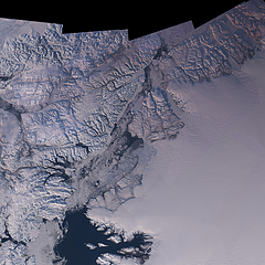
The Nares Strait in Autumn
View information
Landsat mosaic of the Nares Strait between Greenland and Ellesmere Island in Autumn, divided into Baffin Bay, Smith Sound, Kane Basin, Kennedy Channel, Hall Basin and Robeson Channel
| view data | |
|---|---|
| Location: | 67° W, 80.5° N |
| Altitude: | 700 km |
| View Direction: | 0° |
| Camera Angle: | 0° |
| Available size: | up to 48000×48000 pixel |
Catalog inquiry - LicensePrint
Blog news:
Digital Ecosystems and Lobbying (29 Jan 2026)
Musaicum image tiles (16 Jan 2026)
On non-locality in tiled rule based map rendering (15 Jan 2026)
Peeking at peaks (02 Jan 2026)
Todays featured image:

Spring in San Fancisco
The San Fancisco Bay area in April 2016. Image is based on Copernicus Sentinel data from 2016, attribution required. [more]
The most important sections:
Design and Content Copyright 2025 by Christoph Hormann
last updated Sat, 24 May 2025 15:24
