Imagico.de
The Green Marble vegetation map

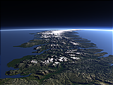
The Green Marble vegetation map shows the amount of vegetation cover, differentiated into woody and herbaceous plants, for every point on the planet. It is produced together with the Green Marble color mosaic and has the same basic properties.
The map is available as a color rendering like shown in the examples or with raw values representing the fractions of the different types of vegetation which can be used for rendering with custom color schemes.
Key properties
- Full coverage of the planet surface up to the poles
- Based on MODIS surface reflectance data, primarily from 2011-2013. Vegetation Continuous Fields (MOD44B) data is used for differentiating vegetation types
- ~250m base resolution
- 8 bit values (256 levels of vegetation fraction)
- Shows the maximum vegetation over the course of the year
- Water areas are filled with nearby values from land so the data is well suited for rendering with generalized waterbody data.
- Available as color rendering or with raw values in any projection
Demo map
Here is a demonstration map in web mercator projection with land coloring based on the Green Marble vegetation map
A small version of the Green Marble vegetation map in plate carrée projection (EPSG:4326) is available for testing under CC-BY-SA license:
- gmv_v10_4326_4800.zip (4.5 MB), usable under Creative Commons Share Alike license
For custom licensing you can obtain any other projection and size of course. For use in web maps i can also provide tile services.
The Green Marble vegetation map license inquiry
Blog news:
Todays featured image: