Imagico.de
Geovisualizations
by Christoph Hormann
The Kashmir Valley
View information

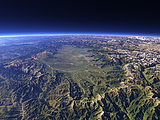
View of the Kashmir Valley from the southeast. Uses waterbody data copyright OpenStreetMap contributors.
| view data | |
|---|---|
| Location: | 75.765° E, 32.992° N |
| Altitude: | 35.863 km |
| View Direction: | 322° |
| Camera Angle: | 57° |
| Available size: | up to 9600×7200 pixel |
Catalog inquiry - LicensePrint
Blog news:
Mapping of populated places in OpenStreetMap (28 Jun 2026)
FOSSGIS Membership Dues – The End of the Story (23 Jun 2026)
FOSSGIS membership fees – Update #3 (18 Jun 2026)
Holding the line – non-locality in map rendering part 2 (06 Jun 2026)
Todays featured image:
The Kashmir Valley
View of the Kashmir Valley from the southeast. Uses waterbody data copyright OpenStreetMap contributors. [more]
The most important sections:
Design and Content Copyright 2026 by Christoph Hormann
last updated Thu, 09 Apr 2026 12:56