Imagico.de
Geovisualizations
by Christoph Hormann
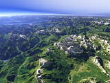
The Tian Shan
View information

View of the Tian Shan at the northern side of the Tarim Basin on the foreground left with the Issyk-Kul lake in the background.
| view data | |
|---|---|
| Location: | 82.047° E, 41.097° N |
| Altitude: | 51.863 km |
| View Direction: | 288.5° |
| Camera Angle: | 38° |
| Available size: | up to 9600×5400 pixel |
Catalog inquiry - LicensePrint
Blog news:
Mapping of populated places in OpenStreetMap (28 Jun 2026)
FOSSGIS Membership Dues – The End of the Story (23 Jun 2026)
FOSSGIS membership fees – Update #3 (18 Jun 2026)
Holding the line – non-locality in map rendering part 2 (06 Jun 2026)
Todays featured image:
The Dolomites near Cortina d’Ampezzo
View of the Dolomites near Cortina d’Ampezzo towards the northwest. Uses data copyright OpenStreetMap contributors and elevation data from Land... [more]
The most important sections:
Design and Content Copyright 2026 by Christoph Hormann
last updated Thu, 09 Apr 2026 12:56