Imagico.de
Geovisualizations
by Christoph Hormann
Spring in San Fancisco
View information

The San Fancisco Bay area in April 2016. Image is based on Copernicus Sentinel data from 2016, attribution required.
| view data | |
|---|---|
| Location: | 122.4° W, 37.75° N |
| Altitude: | 786 km |
| View Direction: | 0° |
| Camera Angle: | 0° |
| Available size: | up to 14000×13000 pixel |
Catalog inquiry - LicensePrint
Blog news:
FOSSGIS membership fees – Update #3 (18 Jun 2026)
Holding the line – non-locality in map rendering part 2 (06 Jun 2026)
Putting animals on the map (24 May 2026)
Update #2 on FOSSGIS membership fees. (22 May 2026)
Todays featured image:
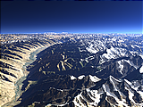
The Wakhan Valley
View of the Wakhan Valley in northeastern Afghanistan - similar to a Views of the Earth image [more]
The most important sections:
Design and Content Copyright 2026 by Christoph Hormann
last updated Thu, 09 Apr 2026 12:56