Imagico.de
Geovisualizations
by Christoph Hormann
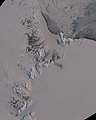
The Southern Alps in New Zealand
View information

View of the Southern Alps on the south Island of New Zealand from the north with its glaciated peaks and the lakes and the braided rivers on the eastern side. Uses data copyright OpenStreetMap contributors and elevation data from LINZ (CC BY 3.0 NZ).
| view data | |
|---|---|
| Location: | 171.005° E, 43.181° S |
| Altitude: | 51.863 km |
| View Direction: | 230° |
| Camera Angle: | 52° |
| Available size: | up to 7200×9600 pixel |
Catalog inquiry - LicensePrint
Blog news:
The ways of the water in OpenStreetMap (10 Apr 2026)
The Musaicum Greenland (01 Apr 2026)
Digital Ecosystems and Lobbying (29 Jan 2026)
Musaicum image tiles (16 Jan 2026)
Todays featured image:
Antarctic spring 2021
Sentinel-2 mosaic of McMurdo sound and dry valleys and the Transantarctic mountain south until Byrd glacier from early in the 2021/2022 observation... [more]
The most important sections:
Design and Content Copyright 2026 by Christoph Hormann
last updated Thu, 09 Apr 2026 12:56