Imagico.de
Geovisualizations
by Christoph Hormann
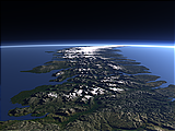
Franz Josef Land in early Spring 2015
View information

Landsat mosaic of Franz Josef Land from late March/early April 2015 with the islands nearly fully snow covered, land fast sea ice between the islands and pack ice around on the ocean.
| view data | |
|---|---|
| Location: | 56° E, 80.7° N |
| Altitude: | 700 km |
| View Direction: | 0° |
| Camera Angle: | 0° |
| Available size: | up to 25000×16333 pixel |
Catalog inquiry - LicensePrint
Blog news:
Holding the line – non-locality in map rendering part 2 (06 Jun 2026)
Putting animals on the map (24 May 2026)
Update #2 on FOSSGIS membership fees. (22 May 2026)
Follow-up on FOSSGIS (01 May 2026)
Todays featured image:
Novaya Zemlya and the Matochkin Strait from south
View of the island of Novaya Zemlya from south with the Matochkin Strait in the middle [more]
The most important sections:
Design and Content Copyright 2026 by Christoph Hormann
last updated Thu, 09 Apr 2026 12:56