Imagico.de
Geovisualizations
by Christoph Hormann
Mount Kilimanjaro
View information

View of Mount Kilimanjaro in Tanzanina, East Africa with low snow cover based on 2013 satellite imagery for the peak.
| view data | |
|---|---|
| Location: | 37.78° E, 2.883° S |
| Altitude: | 19 km |
| View Direction: | 247° |
| Camera Angle: | 54° |
| Available size: | up to 5120×3840 pixel |
Catalog inquiry - LicensePrint
Blog news:
FOSSGIS Membership Dues – The End of the Story (23 Jun 2026)
FOSSGIS membership fees – Update #3 (18 Jun 2026)
Holding the line – non-locality in map rendering part 2 (06 Jun 2026)
Putting animals on the map (24 May 2026)
Todays featured image:
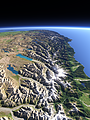
The Southern Alps in New Zealand
View of the Southern Alps on the south Island of New Zealand from the north with its glaciated peaks and the lakes and the braided rivers on the... [more]
The most important sections:
Design and Content Copyright 2026 by Christoph Hormann
last updated Thu, 09 Apr 2026 12:56