Imagico.de
Geovisualizations
by Christoph Hormann
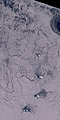
The Bering Strait
View information

View of the Bering Strait between Alaska and Russia from the southeast with Alaska in the foreground, the Aleutian Islands and Kamchatka on the left and the ice covered Arctic Ocean on the right with Wrangel Island and the New Siberian Islands visible.
| view data | |
|---|---|
| Location: | 142.532° W, 49.306° N |
| Altitude: | 2821.86 km |
| View Direction: | 310° |
| Camera Angle: | 42° |
| Available size: | up to 4800×2700 pixel |
Catalog inquiry - LicensePrint
Blog news:
Digital Ecosystems and Lobbying (29 Jan 2026)
Musaicum image tiles (16 Jan 2026)
On non-locality in tiled rule based map rendering (15 Jan 2026)
Peeking at peaks (02 Jan 2026)
Todays featured image:
South Sandwich Islands in Winter 2020
Almost cloud free Sentinel-2 mosaic of the South Sandwich Islands in Winter 2020 showing sea ice reaching very far northward beyond Zavodovski Island [more]
The most important sections:
Design and Content Copyright 2025 by Christoph Hormann
last updated Sat, 24 May 2025 15:24