Imagico.de
Geovisualizations
by Christoph Hormann
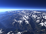
The Bernese and Uri Alps
View information

View of the Bernese and Uri Alps from the Southeast with the Dammastock and Rhône Glacier on the right, the Furka Pass and Grimsel Pass in the center and the Bernese Alps and the upper Rhône valley on the left. Uses data copyright OpenStreetMap contributors.
| view data | |
|---|---|
| Location: | 8.729° E, 46.543° N |
| Altitude: | 5.863 km |
| View Direction: | 280° |
| Camera Angle: | 48° |
| Available size: | up to 5120×3840 pixel |
Catalog inquiry - LicensePrint
Blog news:
Follow-up on FOSSGIS (01 May 2026)
The Saga of FOSSGIS Membership Fees (17 Apr 2026)
The ways of the water in OpenStreetMap (10 Apr 2026)
The Musaicum Greenland (01 Apr 2026)
Todays featured image:
Closeup of the western Caucasus in Winter
Winter view of the western part of the Caucasus mountains with the Kodori Valley in the foreground [more]
The most important sections:
Design and Content Copyright 2026 by Christoph Hormann
last updated Thu, 09 Apr 2026 12:56