Imagico.de
Geovisualizations
by Christoph Hormann
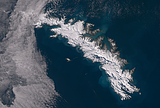
Northeast Greenland in August
View information

Landsat mosaic of the coast of Northeast Greenland in August 2014 showing the eastern edge of the Greenland Ice sheet with the Nioghalvfjerdsbrae and the Zachariae Isstrom, Kronprins Christian Land and the Independence Fjord as well as the coastal and sea ice situation at the height of summer.
| view data | |
|---|---|
| Location: | 21° W, 79° N |
| Altitude: | 700 km |
| View Direction: | 0° |
| Camera Angle: | 0° |
| Available size: | up to 32600×42800 pixel |
Catalog inquiry - LicensePrint
Blog news:
The ways of the water in OpenStreetMap (10 Apr 2026)
The Musaicum Greenland (01 Apr 2026)
Digital Ecosystems and Lobbying (29 Jan 2026)
Musaicum image tiles (16 Jan 2026)
Todays featured image:
South Georgia in early Spring 2021
Sentinel-2 image of South Georgia at the beginning of the 2021-2022 summer season with cloud cover only in the northwest. [more]
The most important sections:
Design and Content Copyright 2026 by Christoph Hormann
last updated Thu, 09 Apr 2026 12:56