Imagico.de
Geovisualizations
by Christoph Hormann
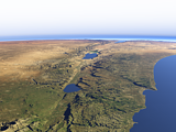
The Ötztal Alps
View information

View of the Ötztal Alps at the border between Italy and Austria from southeast with the Fineilspitze in the foreground left, the Weißkugel on the center left and the heavily glaciated parts around the Gepatschferner in the center. Uses data copyright OpenStreetMap contributors and elevation data from Land Kärnten - data.ktn.gv.at (CC BY 3.0 AT) and from Autonome Provinz Bozen - Südtirol (CC BY 3.0).
| view data | |
|---|---|
| Location: | 10.948° E, 46.769° N |
| Altitude: | 11.863 km |
| View Direction: | 309° |
| Camera Angle: | 66° |
| Available size: | up to 3480×5120 pixel |
Catalog inquiry - LicensePrint
Blog news:
Mapping of populated places in OpenStreetMap (28 Jun 2026)
FOSSGIS Membership Dues – The End of the Story (23 Jun 2026)
FOSSGIS membership fees – Update #3 (18 Jun 2026)
Holding the line – non-locality in map rendering part 2 (06 Jun 2026)
Todays featured image:
The Jordan Valley from north in spring
View of the Jordan Valley in Spring from north with the Golan Heights and Mount Hermon on the foreground left and the Northern Israel and the Sea of... [more]
The most important sections:
Design and Content Copyright 2026 by Christoph Hormann
last updated Thu, 09 Apr 2026 12:56