Imagico.de
Catalog search
Search parameters
Keywords: scand
Style: any
Minimum available size: arbitrary
Longitude: -180° to 180°, Latitude: -90° to 90°
Purpose: for licensing
Results (?)
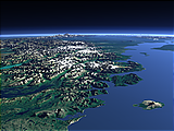
Europe from northwest

View of the central part of Europe from northwest reaching from southern Scandinavia to southern France with Great Britain and Ireland prominently in the foreground. Uses waterbody data copyright OpenStreetMap contributors.
| view data | |
|---|---|
| Location: | 29.007° W, 58.401° N |
| Altitude: | 1321.86 km |
| View Direction: | 108° |
| Camera Angle: | 45° |
| Available size: | up to 9600×5400 pixel |
Western Europe from southeast

View of Western Europe from the southeast from the Iberian Penisula to Italy and Western Scandinavia. Uses waterbody data copyright OpenStreetMap contributors.
| view data | |
|---|---|
| Location: | 16.138° E, 25.347° N |
| Altitude: | 2821.86 km |
| View Direction: | 328.5° |
| Camera Angle: | 35° |
| Available size: | up to 9600×5400 pixel |
Norwegian Coast

View of the northern part of the coast of Norway with the counties of Nordland and Troms and the town of Bodø near the center. In the foreground you can see the bright ice of the Svartisen glacier and on the left behind the Vestfjorden separates the Lofoten from the mainland. Norway only forms a narrow area near the coast and the coastal mountains here, most of the lakes on the right side are already in Sweden. Uses data copyright OpenStreetMap contributors and elevation data from Kartverket (CC-By 4.0).
| view data | |
|---|---|
| Location: | 13.707° E, 66.042° N |
| Altitude: | 111.863 km |
| View Direction: | 34.5° |
| Camera Angle: | 58° |
| Available size: | up to 7200×9600 pixel |
South of Svartisen

Closeup view of the Norwegian coast south of the Svartisen with the town of Mo i Rana on the foreground left. Uses data copyright OpenStreetMap contributors and elevation data from Kartverket (CC-By 4.0).
| view data | |
|---|---|
| Location: | 14.664° E, 66.282° N |
| Altitude: | 11.863 km |
| View Direction: | 302° |
| Camera Angle: | 54° |
| Available size: | up to 5120×3840 pixel |
The Norwegian coast south of Hammerfest

View of the northern Norway coast south of the town of Hammerfest with the Altafjord on the foreground left and the islands Sørøya, Seiland and Stjernøya. Uses data copyright OpenStreetMap contributors and elevation data from Kartverket (CC-By 4.0).
| view data | |
|---|---|
| Location: | 24.975° E, 69.823° N |
| Altitude: | 31.863 km |
| View Direction: | 302° |
| Camera Angle: | 60° |
| Available size: | up to 6400×3600 pixel |
The Norwegian coast east of Tromsø

View of the rugged coast of northern Norway east of the Town of Tromsø with the Lyngen Alps and the Lyngen fjord on the center left. Uses data copyright OpenStreetMap contributors and elevation data from Kartverket (CC-By 4.0).
| view data | |
|---|---|
| Location: | 19.32° E, 68.973° N |
| Altitude: | 31.863 km |
| View Direction: | 46.5° |
| Camera Angle: | 64° |
| Available size: | up to 4800×6400 pixel |
The North Cape

View of the northmost part of mainland Norway around the North Cape from east with the Varangerfjord in the foreground. Uses data copyright OpenStreetMap contributors and elevation data from Kartverket (CC-By 4.0).
| view data | |
|---|---|
| Location: | 30.407° E, 69.992° N |
| Altitude: | 31.863 km |
| View Direction: | 302° |
| Camera Angle: | 61° |
| Available size: | up to 6400×4800 pixel |
Blog news:
Todays featured image: