Imagico.de
Catalog search
Search parameters
Keywords: OpenStreetMap
Style: high altitude views
Minimum available size: arbitrary
Longitude: -180° to 180°, Latitude: -90° to 90°
Purpose: for licensing
Results (?)
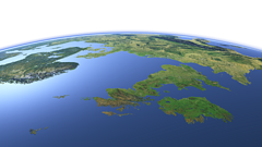
Europe from northwest
View of the central part of Europe from northwest reaching from southern Scandinavia to southern France with Great Britain and Ireland prominently in the foreground. Uses waterbody data copyright OpenStreetMap contributors.
| view data | |
|---|---|
| Location: | 29.007° W, 58.401° N |
| Altitude: | 1321.86 km |
| View Direction: | 108° |
| Camera Angle: | 45° |
| Available size: | up to 9600×5400 pixel |
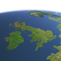
Great Britain and Ireland from southwest
View of View of Great Britain and Ireland from southwest. Uses waterbody data copyright OpenStreetMap contributors.
| view data | |
|---|---|
| Location: | 10.781° W, 44.021° N |
| Altitude: | 1021.86 km |
| View Direction: | 31° |
| Camera Angle: | 35° |
| Available size: | up to 6400×6400 pixel |
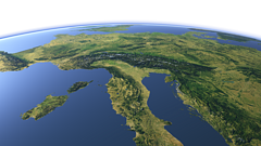
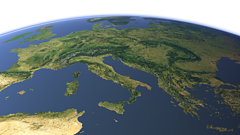
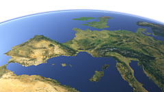
Central Europe from southeast
View of Central Europe from the southeast with the Alps in the middle, Italy in the foreground and France and Germany in the background. Uses waterbody data copyright OpenStreetMap contributors.
| view data | |
|---|---|
| Location: | 19.627° E, 33.353° N |
| Altitude: | 1021.86 km |
| View Direction: | 326° |
| Camera Angle: | 45° |
| Available size: | up to 9600×5400 pixel |
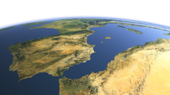
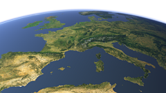
The western Mediterranean Sea
View of the western Mediterranean Sea from southwest with the Iberian peninsula on the left and North Africa on the foreground right. Uses waterbody data copyright OpenStreetMap contributors.
| view data | |
|---|---|
| Location: | 8.83° W, 27.299° N |
| Altitude: | 1021.86 km |
| View Direction: | 32° |
| Camera Angle: | 48° |
| Available size: | up to 9600×5400 pixel |
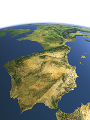
The Iberian peninsula
View of the Iberian peninsula from southwest with the Strait of Gibraltar in the foreground and France in the background. Uses waterbody data copyright OpenStreetMap contributors.
| view data | |
|---|---|
| Location: | 8.207° W, 34.028° N |
| Altitude: | 1021.86 km |
| View Direction: | 32.5° |
| Camera Angle: | 45° |
| Available size: | up to 7200×9600 pixel |
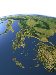
The Balkan Peninsula
View of the Balkan Peninsula from southeast with Greece, western Turkey and the Aegean Sea in the foreground. Uses waterbody data copyright OpenStreetMap contributors.
| view data | |
|---|---|
| Location: | 28.411° E, 32.889° N |
| Altitude: | 1021.86 km |
| View Direction: | 327° |
| Camera Angle: | 45° |
| Available size: | up to 7200×9600 pixel |
Eastern Europe from south
View of Eastern Europe from the south. Uses waterbody data copyright OpenStreetMap contributors.
| view data | |
|---|---|
| Location: | 14.945° E, 21.358° N |
| Altitude: | 2821.86 km |
| View Direction: | 359.5° |
| Camera Angle: | 36° |
| Available size: | up to 9600×5400 pixel |
Western Europe from south
View of Western Europe from the south. Uses waterbody data copyright OpenStreetMap contributors.
| view data | |
|---|---|
| Location: | 6.163° E, 22.298° N |
| Altitude: | 2821.86 km |
| View Direction: | 0.5° |
| Camera Angle: | 35° |
| Available size: | up to 9600×5400 pixel |
Western Europe from southeast
View of Western Europe from the southeast from the Iberian Penisula to Italy and Western Scandinavia. Uses waterbody data copyright OpenStreetMap contributors.
| view data | |
|---|---|
| Location: | 16.138° E, 25.347° N |
| Altitude: | 2821.86 km |
| View Direction: | 328.5° |
| Camera Angle: | 35° |
| Available size: | up to 9600×5400 pixel |
Blog news:
Todays featured image:

